IGNIS | Wildfire Operations
Ignis Technologies
-
Dikemas kini
2026-05-04
-
Versi Semasa
2026.9
-
Ditawarkan Oleh

Penerangan
**Fireline Mapping Transformed with IGNIS**
IGNIS redefines situational awareness, by centralizing essential fireline intelligence, offering unmatched capabilities: overlay GeoPDF maps on dynamic base maps, access curated wildland fire layers, utilize the Fire Weather Dashboard for detailed forecasts, and tap into fire-specific symbology and reference documents. Say goodbye to endless tabs and apps—IGNIS streamlines workflows, saving time and effort in the field.
**Step into the future of firefighting safety today.**
**IGNIS Core: FREE for Firefighters—Because the Right Tools Make a Difference**
Access powerful fire intelligence tools right at your fingertips, so you can focus on what matters most: the task at hand.
**Key Features:**
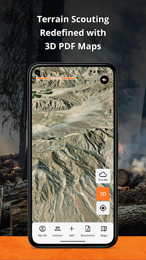
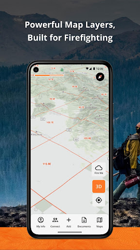
- Store unlimited GeoPDF maps and layer them on dynamic base maps with 3D views.
- Download sections of the base map for offline access.
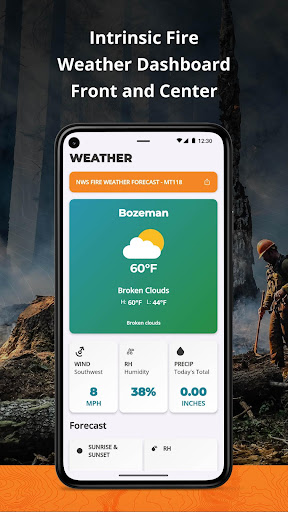
- Access fire-specific weather, including zone forecasts and location-based weather reports.
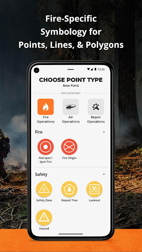
- Build custom incident maps with fire-specific symbology.
- Record tracks, draw lines, drop points, and calculate areas in acres.
- Access essential reference documents directly in the app.
- Curated map layers designed for wildland fire, including:
- Severe Fire Danger Index
- Fire Weather Advisories
- Ground Medevac Transport Times
- Current Incidents
- Current & Historical Fire Perimeters
- NOAA Weather Radar
- ALERTCalifornia Cameras
- Satellite Heat Detection
- Wind Speed & Direction
- And more!
**IGNIS CONNECT: OFFLINE TEAM COLLABORATION**
Take fireline coordination to the next level with IGNIS Connect.
Everything in IGNIS Core, plus:
- Team coordination through offline Bluetooth mesh networking. Share points, lines, and polygons—even without cell service.
- A web app for centralized organization management, document and map sharing, and interactive mapping.
- Unified coordination for field crews and office teams, keeping everyone aligned.
Terms of Use:
https://www.ignistech.io/terms-of-use
[](https://www.ignistech.io/terms-of-use)Privacy Policy:
https://www.ignistech.io/privacy-policy
Get Help or Leave Feedback:
https://help.ignistech.io/
Or email contact@ignistech.io
IGNIS redefines situational awareness, by centralizing essential fireline intelligence, offering unmatched capabilities: overlay GeoPDF maps on dynamic base maps, access curated wildland fire layers, utilize the Fire Weather Dashboard for detailed forecasts, and tap into fire-specific symbology and reference documents. Say goodbye to endless tabs and apps—IGNIS streamlines workflows, saving time and effort in the field.
**Step into the future of firefighting safety today.**
**IGNIS Core: FREE for Firefighters—Because the Right Tools Make a Difference**
Access powerful fire intelligence tools right at your fingertips, so you can focus on what matters most: the task at hand.
**Key Features:**
- Store unlimited GeoPDF maps and layer them on dynamic base maps with 3D views.
- Download sections of the base map for offline access.
- Access fire-specific weather, including zone forecasts and location-based weather reports.
- Build custom incident maps with fire-specific symbology.
- Record tracks, draw lines, drop points, and calculate areas in acres.
- Access essential reference documents directly in the app.
- Curated map layers designed for wildland fire, including:
- Severe Fire Danger Index
- Fire Weather Advisories
- Ground Medevac Transport Times
- Current Incidents
- Current & Historical Fire Perimeters
- NOAA Weather Radar
- ALERTCalifornia Cameras
- Satellite Heat Detection
- Wind Speed & Direction
- And more!
**IGNIS CONNECT: OFFLINE TEAM COLLABORATION**
Take fireline coordination to the next level with IGNIS Connect.
Everything in IGNIS Core, plus:
- Team coordination through offline Bluetooth mesh networking. Share points, lines, and polygons—even without cell service.
- A web app for centralized organization management, document and map sharing, and interactive mapping.
- Unified coordination for field crews and office teams, keeping everyone aligned.
Terms of Use:
https://www.ignistech.io/terms-of-use
[](https://www.ignistech.io/terms-of-use)Privacy Policy:
https://www.ignistech.io/privacy-policy
Get Help or Leave Feedback:
https://help.ignistech.io/
Or email contact@ignistech.io
Tunjukkan Lagi
OTHERS:MAP_AND_NAVIGATION
Apa yang Baru dalam Versi 1.3.5
Kemaskini terakhir pada May 04,2026
Pembaikan pepijat kecil dan penambahbaikan. Pasang atau kemas kini ke versi terbaru untuk mencubanya!
Kurangkan
tangkapan skrin
Maklumat
-
Dikemas kini2026-05-04
-
Versi Semasa2026.9
-
Ditawarkan Oleh

-
saiz pekej aplikasi0MB
-
Memerlukan AndroidAndroid 4.4+